本文转自《WYOMING PUBLIC MEDIA》发表的题为“CO2 Pipeline Network Aimed At Supporting Carbon Capture Moves Forward”的报道
作者:COOPER MCKIM
日期:2020.04.17
原文链接:https://www.wyomingpublicmedia.org/post/co2-pipeline-network-aimed-supporting-carbon-capture-moves-forward#stream/0

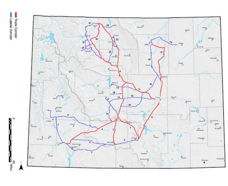
A map of the proposed CO2 pipeline corridors from the draft environmental impact statement released April 17
CREDIT BUREAU OF LAND MANAGEMENT
A project meant to support carbon capture and enhanced oil recovery in Wyoming has passed a regulatory hurdle. The Bureau of Land Management (BLM) released its draft Environmental Impact Statement (DEIS) for the Wyoming Pipeline Corridor Initiative (WPCI). It's now seeking public comment.
The WPCI was initially proposed in 2012 as part of former Gov. Matt Mead's energy strategy. It aims to establish a 1,914 mile-network of pipeline corridors along private, state and BLM land. It would connect carbon dioxide to various oil fields, particularly ones considered "played out," or developments in need of carbon dioxide.
Similar to the Integrated Test Center in Gillette, the WPCI aims to give companies access to emissions that would otherwise go into the atmosphere and make something valuable out of it.
The WPCI found the use of enhanced oil recovery (EOR) has the potential to produce up to about 1.8 billion barrels of oil. The process improves production by injecting a substance into the ground that increases pressure and things out the oil. Last year, Wyoming produced just over 101 million barrels of crude oil in total.
The initiative will not develop pipelines itself. It's intended to make environmental analysis easier for future developers by coordinating nine resource management plans and laying the boundaries for the corridor.
"We've done the heavy lifting to disclose the majority of impacts, that the company could come in and fall underneath of our analysis, do less analysis because we've already covered it," said Matt Fry, the project manager for the WPCI.
Fry worked with Mead on the project initially. He said it's been in the works since 2010. In 2012, the Wyoming legislature allocated $2 million to pursue the project further. Since then, it's been in the planning process. Fry said that's likely due to the project being unique.
"The fact that it's never been done before was a big hindrance in actually getting the inertia to move it forward," he said.
The project is in line with efforts from Gov. Mark Gordon as well. This past legislative session, the Governor's office testified in favor of House Bill 200; that bill pushes for the integration of carbon capture, utilization and sequestration into coal-fired power plants. Gordon's office is supportive of the WPCI effort and plans to review the draft EIS.
In the initial scoping period, the BLM heard from 33 entities including businesses and state agencies. Converse County expressed optimism at the opportunity to work with CO2. The Power Company of Wyoming pointed to traffic concerns if built south of Rawlins.
The Western Watersheds Project (WWP), along with four other environmental groups, emphasized in its comments the need for proper calculation of climate impacts, impact to tribal land, and proximity to greater sage-grouse habitat and wildlife habitat in general. A representative from one of the groups said it's still too early to judge whether the DEIS resolved concerns while raising the need to specify where the CO2 was coming from.
BLM identified its fourth and final alternative as the preferred path forward. The option would dedicate portions of corridors and create new ones meant solely for the transport of CO2 and EOR Products.
"Routes would be modified or eliminated from the Proposal to avoid resource conflicts, Sage Grouse PHMA [priority habitat management areas], pre-existing rights, existing uses and infrastructure," read the federal register referring to Alternative D.
The public comment period starts on Friday, April 17 and lasts for 90 days.
Have a question about this story? Contact the reporter, Cooper McKim, at cmckim5@uwyo.edu.